Route South through Chile and Southern Argentina
Santiago to Araucan

Araucan to Coihaique

Coihaique to Puerto Natales

I rode the 1200km of the Carretera Austal (see highlights below) over a month (Feb/Mar) to Villa O’Higgins before doubling back to cross the first border I could take to Argentina (Paso Roballos by Chile Chico), after that I picked up the (generally gravel) Ruta 40 through Baja Caricoles, Gobernador Gregores, Tres Lagos, El Chaiten, El Calafate and Veintiocho de Noviembre before crossing back into Chile for Puerto Natales.
I spend 4 days waiting for a good weather window there and managed to get a full day loop in Torres del Paine National Park (360km trip) before I took the 3 day journey of Navimag ferry that same night back along the Fjords to Puerto Montt.

There was plently of non-moto activites too; there are National Parks to hike in, horse riding trips (if you’re into that) to be taken and villages/ towns to drop into for lunch – don’t forget the strange little town of Caleta Tortel for a visit. Once at O’Higgins, you can take the 12 hour return trip by boat to see the ice sheet.

Theres a few paved sections in the northern-most part of the Carretera which are quite a nice break from the dusty gravel

Random little food places


..and deep gravel


There are plenty of little off shoot tracks to explore


Camping near Puerto Gardal beside Lago General Carrera

This route that formed my first crossing into Argentina was just spectacular – traversing the length of Lago General Carreta, the change in scenery was quite dramatic, from the blue lakes and white peaks on the Chilean side to the dry Argentinean pampas. I must’ve stopped at every corner to take a photo. I think I passed one vehicle the whole ride.


Argentina to the east of the Andes is very flat


Highlight: Day trip out to Torres del Paine from Puerto Natales
I spend 4 days waiting for a good weather window there and managed to get a full day loop in Torres del Paine National Park (360km trip) before I took the 3 day journey of Navimag ferry that same night back along the Fjords to Puerto Montt.
I crossed back into Argentina after up Volcan Osorno and out through Puyehue National Park, rode South to San Carlos de Bariloche (the hiking here is incredible) and El Bolson (to meet a friend) and then doubled back to ride around the famous Siete Lagos and towns of Villa la Angostura and San Martin de los Andes.
Heading north, we crossed back into Chile besides Volcan Lanin and Volcan Villaricca (near Pucon) where I spent a few days with a couple friends riding round the lakes and the volcanoes. Heading north back to Santiago, I took the inland and coast roads to avoid the motorway, stopping at Pilchelmu and Valparaiso. Then back into Santiago (logistical reasons) and then out to cross again into Argentina over the 4000m high Los Libertadores/Cristo Redentor pass just below Mt Aconcagua (the Andes highest mountain at~7000m elev.)
Heading north, we crossed back into Chile besides Volcan Lanin and Volcan Villaricca (near Pucon) where I spent a few days with a couple friends riding round the lakes and the volcanoes. Heading north back to Santiago, I took the inland and coast roads to avoid the motorway, stopping at Pilchelmu and Valparaiso. Then back into Santiago (logistical reasons) and then out to cross again into Argentina over the 4000m high Los Libertadores/Cristo Redentor pass just below Mt Aconcagua (the Andes highest mountain at~7000m elev.)
Highlight: Carretera Austral (1200km, 1 month)
Spanning over 2 lines of latitude, the Carretera Austral at 1200km is a monster ride. I'd advise taking as much time you can down there as, if you like to take photos, you’l be stopped a lot for that reason.
The riding consists of three quarters gravel roads (sometimes deep gravel – stay in the ruts!) through green and heavily vegetated hilly terrain giving way to exposed mountain slopes and more and more blue, blue lakes the further south you go.
The mountains are the base of the Andean range of which there are steep, sharp peaks and hanging glaciers with lots of milky blue glacial fed rivers to cross.
There are four ferries to take, three within the first 1-2 days and the fourth is ~100km out of Villa O'Higgins.
Villa O’Higgins at the far south of the Carreterra is the jumping off point for trips to the Patagonian Ice Fields.
I went mid-March to mid-Feb, the weather was good; clear and dry mostly with the odd few days of rain that I would just hole up for (being that you can’t see anything when it rains, and that was the reason for my visit), so put a few days aside for just this.
Looking back, I would have gone earlier if possible (they say January is good) which may have prevented me hitting the harsh weather in Southern Argentina when I crossed the border.
It got cold though, the further south I went. During the day it would have been comfortable but when the sun went down (about 11pm at that time of year) it was chilly.

I didn’t carry extra fuel nor did I worry about where I would pick up supplies as there’s little towns/ villages/ random tea rooms/ bakeries along the way.
Accommodation wise, I camped mostly (generally quiet campsites) and stayed in some cheap hospedajes, both of which, there are adequate options for.
Of the places I stayed these I would definitely recommend Las Torres del Simpson (camping, on Ioverlander) and Villa Cerro Castillo (camping/bunk cabin, in the Lonely Planet).
Theres also a family run campsite just around the Lake (2-3kms East) of Puerto Guadal with the most magnificent view to wake up to).
The second ferry below over is the longest (a few hours)

There was plently of non-moto activites too; there are National Parks to hike in, horse riding trips (if you’re into that) to be taken and villages/ towns to drop into for lunch – don’t forget the strange little town of Caleta Tortel for a visit. Once at O’Higgins, you can take the 12 hour return trip by boat to see the ice sheet.

Theres a few paved sections in the northern-most part of the Carretera which are quite a nice break from the dusty gravel

Random little food places

Some areas in the northern section can be quite densely vegetated


Cerro Castillo


Cerro Castillo

Plenty of windy roads..

..and deep gravel


There are plenty of little off shoot tracks to explore

The last (fourth) ferry

The last section to Villa O'Higgins; do expect to see rock falls and general construction along the route

Patagonian ice sheet via boat from the most southerly point of the Carretera Austal at Villa O'Higgins


Heading back north from O'Higgins


Caleta Tortel is a magical little place

Oh the dust!


Camping near Puerto Gardal beside Lago General Carrera

Highlights: Paso Roballes from the Carretera Austral (Puerto Guardal to Chile Chico, 100km)
And one of the highlights of the highlight(!) was the dirt route out to the Chile- Argentina border from Puerto Guardal to Chile Chico – if you don’t cross here you can just double back to the Carretera Austral, it’s certainly worth it.This route that formed my first crossing into Argentina was just spectacular – traversing the length of Lago General Carreta, the change in scenery was quite dramatic, from the blue lakes and white peaks on the Chilean side to the dry Argentinean pampas. I must’ve stopped at every corner to take a photo. I think I passed one vehicle the whole ride.


Southern Argentina (Chile Chico to Puerto Natales)
What an incredible change of scenery! This photo was taken after I crossed the border into Argentina.
Onward and south now, through Baja Caricoles, Gobernador Gregores, Tres Lagos, El Chaiten, El Calafate and Veintiocho de Noviembre before crossing back into Chile for Puerto Natales.

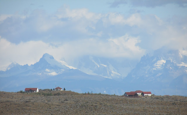
Argentina to the east of the Andes is very flat

Heading into El Chalten with some argentinean boys id met at the campsite in Goberador


Casa de las cyclistas in El Chalten - I do wonder if this place is still here (its kind of a community style hostel for cyclists where we stayed below)

Heading to the National Park to visit Perito Moreno glaciar


El Perito Moreno


This was a huge day on the little bike and I just about managed it whilst scared of running out of fuel and missing the 8pm Fjord ferry on the way back to Punta Arenas. It was perhaps 280km round trip, I entered into the national park at the south exit and looped around to the northern exit before returning back to Peurto Natales.


Comments
Post a Comment